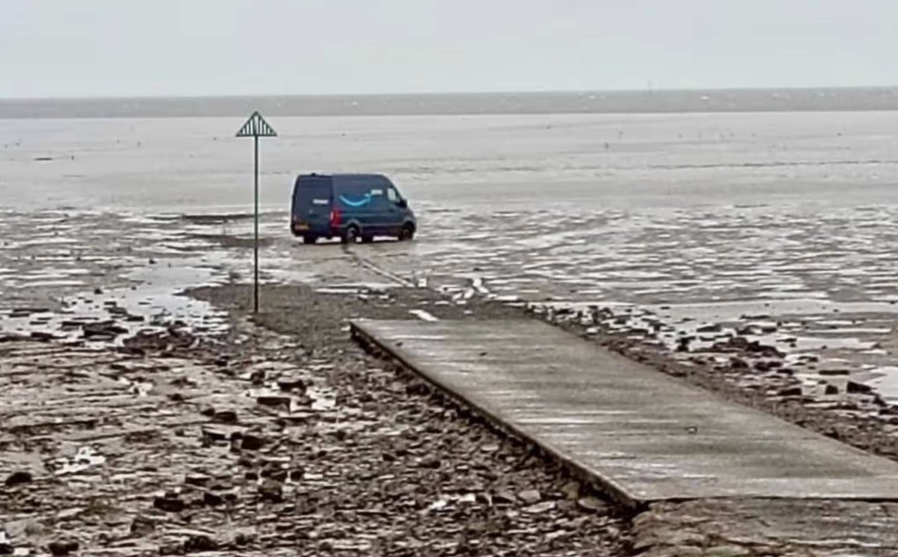
An Amazon-branded delivery van was left stranded on exposed tidal mudflats off the Essex coast on 15 February 2026, after its driver reportedly followed GPS directions onto The Broomway—a six-mile tidal path often described as Britain's most dangerous walk. The vehicle became stuck in soft coastal mud, requiring emergency services to attend and a local farmer to arrange recovery.
Both the driver and passenger exited the vehicle safely before the tide posed a threat. HM Coastguard Southend confirmed no injuries occurred and no pollution risk was identified. The incident serves as a stark reminder of the limitations of satellite navigation technology, particularly in remote coastal areas with restricted access.
For van drivers making deliveries across the UK—whether for major logistics firms or independent operators browsing listings on marketplaces like OnlyVans—understanding route planning and local geography remains essential, even in an age of advanced navigation systems.
What Happened: The Incident Breakdown
The Amazon van stuck in sea mud was discovered on the morning of Sunday 15 February, though the incident reportedly occurred the previous evening. The driver had been attempting to reach Foulness Island, a former military testing site on the Thames Estuary, still owned by the Ministry of Defence and managed by defence contractor QinetiQ.
Rather than directing the driver to the official security barrier entrance, the GPS system routed the vehicle via Wakering Stairs—a public access point leading onto The Broomway. This historic tidal crossing is a shifting, unmarked path that becomes submerged or impassable depending on tide levels and weather conditions.
The van continued onto the mudflats, where it became firmly lodged in soft coastal mud. By the time emergency services were alerted, the vehicle was sitting alone on exposed estuary ground, surrounded by tidal channels with no conventional road surface visible.
Why The Broomway Is So Dangerous
The Broomway stretches approximately six miles from the Essex mainland into the Thames Estuary. Historically, it has been linked to over 100 drownings, earning its reputation as one of Britain's most treacherous coastal paths. The route is unmarked, shifts with tidal movements, and can be cut off rapidly by rising water.
Even experienced walkers avoid The Broomway without a knowledgeable local guide. The path is only accessible when Ministry of Defence firing ranges on Foulness Island are inactive, and the ground becomes unstable depending on weather and tide. Icy conditions had been forecast across parts of Essex around the time of the incident, which may have contributed to surface instability.
Key Hazards of The Broomway
- ✓No conventional road surface—only shifting sand and mud
- ✓Completely submerged at high tide
- ✓Unmarked route with no signage or lighting
- ✓Access restricted by MOD firing range schedules
- ✓Soft ground unsuitable for vehicle weight
- ✓Rapid tidal changes can trap walkers and vehicles
The Emergency Response
HM Coastguard Southend was notified once the Amazon van in sea mud was discovered. Coastguard teams contacted QinetiQ security, who manage access to Foulness Island, to coordinate a safe response. Fortunately, both the driver and passenger had already exited the vehicle and reached safety before emergency services arrived.
With no injuries reported and no immediate pollution risk from the stranded vehicle, Amazon arranged for a local farmer familiar with the terrain to recover the van. The coastguard stood down once occupants were confirmed safe and recovery plans were in place. The operation was scheduled for Sunday afternoon, timed to coincide with favourable tidal conditions.
GPS Navigation and Commercial Vans: Lessons for Drivers
This incident highlights a growing challenge for commercial van drivers: over-reliance on GPS technology without considering vehicle suitability or terrain. Satellite navigation systems typically prioritise the shortest route, which may include footpaths, bridleways, or tidal crossings unsuitable for motor vehicles.
Drivers operating large vans—whether Ford Transits, Mercedes Sprinters, or Volkswagen Crafters commonly listed on platforms like OnlyVans—should ensure their navigation settings specify commercial vehicle routing. This filters out unsuitable roads based on weight, height, and width restrictions.
Frequently Asked Questions
Where exactly did the Amazon van get stuck?
The van became stuck on The Broomway, a six-mile tidal crossing on the Essex coast leading into the Thames Estuary. The driver accessed the route via Wakering Stairs, following GPS directions towards Foulness Island. The Broomway is a historic footpath that becomes submerged at high tide and is completely unsuitable for vehicles.
Was anyone injured in the incident?
No injuries were reported. Both the driver and passenger exited the vehicle safely before emergency services arrived. HM Coastguard Southend confirmed all occupants were safe and stood down once Amazon arranged recovery through a local farmer familiar with the terrain.
Why did GPS direct the driver onto a tidal path?
Standard GPS systems often prioritise the shortest route without distinguishing between vehicle-suitable roads and footpaths. The Broomway appears on maps as a coastal access route to Foulness Island, but it's a tidal crossing with no paved surface. Commercial vehicle GPS settings, which filter routes by weight and vehicle type, may have prevented this error.
Can The Broomway be used by vehicles at all?
No. The Broomway is a tidal footpath with shifting sand and mud, completely unsuitable for motor vehicles. It becomes submerged at high tide and is dangerous even for experienced walkers without a guide. Foulness Island has an official vehicle entrance through a QinetiQ security barrier—The Broomway is not an authorised access route.
What should van drivers do if GPS suggests an unusual route?
Stop and verify the route before proceeding. Check satellite imagery, consult a paper map, or contact the delivery recipient for clarification. If a route directs you onto an unmade track, coastal path, or area with warning signs about tides or military activity, do not continue. Trust your instincts over the GPS.
How much damage does saltwater cause to vans?
Saltwater exposure can cause severe corrosion to a van's undercarriage, engine components, electrical systems, and braking mechanisms. Even if a vehicle is recovered quickly, saltwater can lead to long-term reliability issues and expensive repairs. In many cases, insurance assessors may write off vehicles exposed to seawater due to the extent of potential hidden damage.
Final Thoughts
The Amazon van stuck in sea mud on the Essex coast is a cautionary tale about the limitations of GPS technology and the importance of driver awareness. While satellite navigation has transformed logistics and delivery efficiency, it cannot replace local knowledge, common sense, or proper route verification.
For van operators across the UK—whether running independent courier services or managing fleets—investing in commercial-grade navigation, driver training, and situational awareness protocols can prevent costly and potentially dangerous incidents. The Broomway may be an extreme example, but similar risks exist on narrow rural lanes, low bridges, and weight-restricted roads throughout Britain.
If you're in the market for a reliable delivery van or looking to sell your current vehicle, OnlyVans offers a straightforward marketplace to browse listings, compare specifications, and connect with buyers and sellers across the UK. Whether you need a compact van for city deliveries or a long-wheelbase model for rural routes, understanding your vehicle's capabilities and limitations is just as important as finding the right deal.